SAN FRANCISCO VOLCANIC FIELD
NORTHERN
ARIZONA
The obsidian sources within this field are, perhaps, the best studied in
the Arizona, at least early on (Jack 1971; Peterson 2013; Robinson 1913; Sanders et al. 1982; Schreiber and Breed 1971;
Shackley 1988, 2005). Although the chemical variability within sources in this field is
generally less than in the mid-Tertiary sources to the south, the magmatic relationships
between some of these sources as previously reported are probably in error (Jack 1971;
Sanders et al. 1982). Based on K-Ar dates, the obsidian and rhyolite
from these sources varies between 2.70 Ma at Government Mountain to 1.10
from the obsidian on the San Francisco Peaks (McKee et al. 1998).
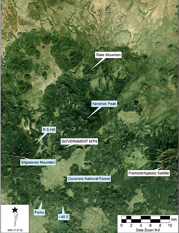 Sources of archaeological obsidian in the San Francisco
Volcanic Field
Sources of archaeological obsidian in the San Francisco
Volcanic Field
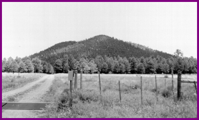
The coalesced rhyolite domes
known as Government Mountain (view from the south, 1980s)
Government Mountain. Sections
24, 25 R4E, T22N and Sections 19, 20, 29, 30, R5E, T22N USGS Parks 7.5' Quad, Kaibab
National Forest, south central Coconino County, Arizona (updated 6.25.98). This
is, as noted earlier, perhaps the best known contemporary obsidian source in Arizona.
Shackley (2005), however, showed that RS Hill glass may be equally common in Preclassic
Hohokam contexts in central Arizona. Government Mountain is a single rhyolite dome that
exhibits rhyolite/tuff/obsidian within the alluvium around the base of the dome structure.
Even after years of modern and prehistoric collection, nodules up to 15 cm in diameter are
common. Most nodules exhibit little cortex, per se, but some are covered with ash from the
alluvium or exhibit a thin gray or brown weathered surface. The glass is aphyric, but the
fabric is megascopically granular and distinctive, apparently from microphenocrysts of
alkali feldspar and iron oxide (Burton 1986; Wolfe et al. 1987:13). Some lighter gray and more vitreous material
was recovered on the south slope. Thin flakes are cloudy gray when viewed with transmitted
light. Secondary deposition occurs only within a short distance (2 km) around the base and
is most noticeable south into Government Prairie.
A K-Ar at 2.70±0.08 Ma was derived
from obsidian on the west side of the dome, where much of the obsidian for this
analysis was collected (McKee et al. 1998).
Reduced cobbles and flakes are very abundant and densities of cultural
obsidian reach 200 per 5m2 in places, especially on the west and south slopes;
some portion of this, however, is modern reduction from local knappers. Bifacial core preforms
also occur sporadically on the dome, and most are broken (usually lateral snap-fractures).
No other artifactual material was observed. Published references are the same as for the
previous San Francisco sources, although Robinson only mentions it in passing (1913:67).
Update June 2004: I sampled the dome complex toward the top of
the domes and on the north side. Analysis of many archaeological data from this
source suggested lower Rb values and higher Zr values than the original 10
source standards. At the base of the north side of the complex a number of
banded nodules were located. Some of these exhibited the lower Rb values
evident in the archaeological record. The table below reflect the mean and
central tendency for the original 10 source standards and 14 additional samples
from near the top of the dome complex and the north side.
Update August 2014: With Jeff Ferguson (U Missouri) and
Kathy Butler, re-investigated the dome complex around the circumference and up
on the west slope. Outcrops of ashy, perlitic lava did exhibit obsidian
strata, and like many rhyolite domes that produced obsidian, much of the
obsidian zone appears to be eroding downslope (see images below). One
additional sample (080514-2-1) was analyzed and included here.
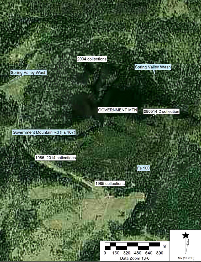
Collection localities at Government Mountain (1985-2014).
Fs=Forest road designation.
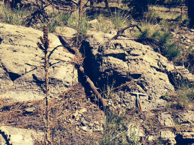 Ashy perlitic lava with obsidian strata above rock hammer
at collection 080514-2.
Ashy perlitic lava with obsidian strata above rock hammer
at collection 080514-2.
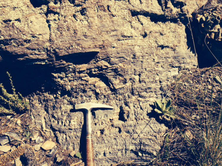
Close-up of obsidian strata from above image.
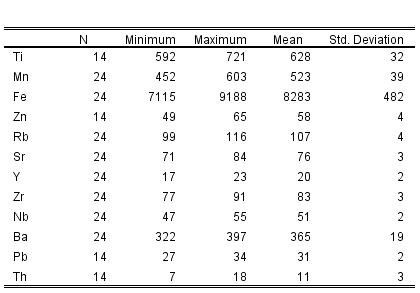
Elemental concentrations for Government
Mountain source standards. All measurements in parts per million (ppm). GM
prefix samples collected in the 1980s. 06 or 08 prefix are date and sample
collection numbers.*
|
Sample |
Ti |
Mn |
Fe |
Zn |
Rb |
Sr |
Y |
Zr |
Nb |
Ba |
Pb |
Th |
|
080514-2-1 |
792 |
473 |
9536 |
54 |
106 |
81 |
21 |
73 |
51 |
363 |
30 |
13 |
|
061504-1-1 |
609 |
464 |
7421 |
53 |
99 |
74 |
17 |
79 |
48 |
379 |
29 |
18 |
|
061504-1-2 |
592 |
452 |
7115 |
49 |
99 |
71 |
21 |
77 |
47 |
386 |
27 |
9 |
|
061504-1-3 |
616 |
529 |
8131 |
61 |
107 |
73 |
22 |
86 |
49 |
369 |
32 |
10 |
|
061509-1-4 |
600 |
514 |
8332 |
59 |
108 |
73 |
18 |
91 |
50 |
359 |
34 |
10 |
|
061509-1-5 |
613 |
531 |
8305 |
61 |
106 |
75 |
18 |
84 |
48 |
334 |
31 |
7 |
|
061509-1-6 |
721 |
532 |
8255 |
58 |
108 |
72 |
18 |
85 |
49 |
383 |
34 |
13 |
|
GM-11 |
628 |
533 |
8259 |
56 |
105 |
78 |
23 |
85 |
51 |
351 |
33 |
10 |
|
GM-12 |
630 |
496 |
7998 |
57 |
107 |
74 |
19 |
86 |
51 |
397 |
32 |
14 |
|
GM-13 |
627 |
546 |
8417 |
62 |
105 |
77 |
20 |
86 |
52 |
367 |
31 |
9 |
|
GM-14 |
652 |
544 |
8576 |
65 |
107 |
79 |
19 |
86 |
53 |
378 |
33 |
9 |
|
GM-15 |
641 |
507 |
8005 |
59 |
105 |
74 |
22 |
83 |
53 |
396 |
31 |
12 |
|
GM-16 |
646 |
487 |
8026 |
57 |
108 |
75 |
18 |
82 |
49 |
322 |
30 |
10 |
|
GM-17 |
607 |
475 |
7605 |
55 |
101 |
75 |
17 |
83 |
48 |
380 |
29 |
13 |
|
GM-18 |
614 |
504 |
8126 |
57 |
106 |
76 |
20 |
82 |
51 |
375 |
32 |
8 |
|
GMA |
|
564 |
9037 |
|
111 |
78 |
19 |
84 |
54 |
348 |
|
|
|
GMB |
|
601 |
8946 |
|
111 |
79 |
21 |
79 |
52 |
351 |
|
|
|
GMC |
|
540 |
8484 |
|
109 |
77 |
18 |
82 |
55 |
350 |
|
|
|
GMD |
|
528 |
8410 |
|
107 |
79 |
21 |
82 |
53 |
362 |
|
|
|
GME |
|
603 |
9188 |
|
116 |
84 |
20 |
82 |
54 |
344 |
|
|
|
GMF |
|
554 |
8821 |
|
109 |
78 |
19 |
82 |
52 |
374 |
|
|
|
GM1 |
|
537 |
8477 |
|
108 |
78 |
19 |
81 |
55 |
364 |
|
|
|
GM2 |
|
492 |
8347 |
|
107 |
80 |
19 |
84 |
51 |
366 |
|
|
|
GM3 |
|
550 |
8559 |
|
106 |
79 |
22 |
81 |
54 |
369 |
|
|
|
GM4 |
|
468 |
7955 |
|
104 |
75 |
18 |
78 |
48 |
351 |
|
|
Mean and
central tendency for data in table above
Oxide values for one Government Mountain sample
|
Sample |
SiO2 |
Al2O3 |
CaO |
Fe2O3 |
K2O |
MgO |
MnO |
Na2O |
TiO2 |
|
Government Mtn |
|
|
|
|
|
|
|
|
|
|
080514-2-1 |
75.87 |
13.431 |
0.7936 |
0.9335 |
4.317 |
<.001 |
0.0809 |
4.43 |
<.001 |
|
RGM1-S4 |
74.00 |
13.073 |
1.4097 |
2.163 |
4.885 |
<.001 |
0.0482 |
3.91 |
0.258 |
* Cow Canyon and
Government Mountain exhibit similar chemistry in a number of elements. They are
megascopically distinctive and Ti, Zr, Nb, and Ba effectively separate these two sources.
Sitgreaves Mountain. Sections
7,13,14 R3E, T23N USGS Williams 15' Quad; Sections 16,17,19,20,24,25,31,32,36 R4E, T22N
USGS Moritz Ridge and Parks 7.5' Quads. Kaibab National Forest, south central Coconino
County, Arizona. Sitgreaves Mountain (or Peak) is the largest single mass of rhyolite in
the San Francisco field (Robinson 1913). Abundant eroded cobbles of obsidian are present
around the flanks of this mountain. Some of the cobbles are up to 20 cm in diameter. The
nodules are part of a rhyolite/tuff/obsidian alluvium and densities up to 10 per m2
were recorded. No obsidian was recorded 'in situ' or in large blocks toward the peak.
There appears to be no appreciable secondary deposition, although the eroded material in
Spring Valley is chemically identical to both Sitgreaves and RS Hill. The rounded nodules
exhibit a tan to brown cortex and a lustrous, but somewhat micro-granular interior. The
glass is slightly vitrophyric with uncommon alkali-feldspar phenocrysts up to 3 mm in
diameter. The glass is near opaque and gray with thin flakes exhibiting a cloudy gray
pattern. This material, while similar to RS Hill and Government Mountain obsidian does not
reduce as efficiently and the large sparse phenocrysts hamper control. Obsidian
dated by K-Ar on the southeast side of Sitgreaves near RS Hill yielded a date of
2.84 ± 0.02 Ma (McKee et al. 1998).
The nodules were frequently reduced at the source and flakes occur
throughout the source area, but no intensive reduction areas were located. Published
sources include Jack (1971); Moore et al. (1960); Robinson (1913); Sanders et al. (1982);
Schreiber and Breed (1971).
RS Hill. Sections 15, 16, 21, 22, 28, 27
R4E, T22N USGS Parks 7.5' Quad, Kaibab National Forest, south central Coconino County,
Arizona. This is a relatively small rhyolite dome that produced the largest nodules
recovered in this study (35 cm in diameter). The nodules are similar to those from
Sitgreaves, but not as eroded and therefore generally more angular. Gray cortex
predominates. The fabric is also megascopically vitrophyric and micro-granular with sparse
alkali-feldspar phenocrysts up to 3 mm in diameter. The glass however, is frequently
blacker, more vitreous and a higher quality knapping obsidian. The fabric looks
megascopically very similar to Government Mountain, but is not entirely aphyric. Secondary
deposition occurs as slope wash into the Spring Valley Wash system, but the material is
only transported a few kilometers south. Reduction of the nodules is very common and flake
densities approach 100 per 5m2 in places. Published references are the same as
for Sitgreaves.
Revisit and resampling 4 August 2014:
Surveyed and
sampled up to near the top of the RS Hill dome. Collected samples on the
east and west slope, as well as the top of the ridge (the 080414-4 samples
below). Nodule size on top of dome was up to over 10 cm, with some near 15
cm in very high density. Due to managed fires on Sitgreaves Mountain, we
were denied access, but the samples from the west side of RS Hill are up against
Sitgreaves (see map here). Given the complete overlap of elemental
concentrations between Sitgreaves and RS Hill this isn't an issue for source
assignment. Certainly RS Hill is a vent dome from the larger Sitgreaves
Mountain dome complex. The original (1980s) RS Hill samples (RSW for west
slope, and RSS for southslope) were collected along the forest roads (see image
below).
Mean and central tendency for RS Hill/Sitgreaves
samples
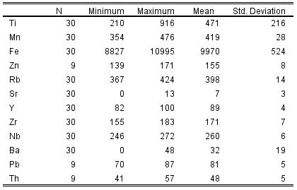
Raw elemental concentrations for Sitgreaves
Mountain (SM) and RS Hill (RS) source standards. All measurements in parts per million
(ppm).
|
Sample |
Ti |
Mn |
Fe |
Zn |
Rb |
Sr |
Y |
Zr |
Nb |
Ba |
Pb |
Th |
|
SM1 |
415 |
374 |
9906 |
|
410 |
7 |
94 |
174 |
269 |
42 |
|
|
|
SM2 |
529 |
417 |
10335 |
|
402 |
8 |
95 |
173 |
259 |
43 |
|
|
|
SM3 |
316 |
381 |
9091 |
|
385 |
9 |
87 |
176 |
254 |
45 |
|
|
|
SM4 |
300 |
424 |
9255 |
|
391 |
8 |
86 |
174 |
257 |
44 |
|
|
|
SM5 |
371 |
397 |
8827 |
|
376 |
8 |
83 |
165 |
246 |
45 |
|
|
|
SM6 |
317 |
462 |
9609 |
|
408 |
4 |
89 |
180 |
262 |
46 |
|
|
|
SM7 |
282 |
462 |
10012 |
|
406 |
6 |
88 |
174 |
263 |
43 |
|
|
|
SM8 |
290 |
444 |
9621 |
|
387 |
5 |
84 |
168 |
251 |
48 |
|
|
|
SM9 |
277 |
413 |
9346 |
|
387 |
6 |
86 |
177 |
252 |
41 |
|
|
|
SM10 |
276 |
456 |
9718 |
|
404 |
5 |
89 |
183 |
262 |
41 |
|
|
|
RSW1 |
450 |
427 |
10543 |
|
424 |
0 |
100 |
180 |
265 |
45 |
|
|
|
RSW2 |
358 |
430 |
10723 |
|
423 |
8 |
93 |
176 |
271 |
45 |
|
|
|
RSW3 |
507 |
354 |
9822 |
|
396 |
6 |
92 |
168 |
260 |
47 |
|
|
|
RSW4 |
491 |
421 |
10610 |
|
415 |
7 |
94 |
178 |
264 |
43 |
|
|
|
RSW5 |
482 |
404 |
10332 |
|
411 |
0 |
94 |
175 |
263 |
44 |
|
|
|
RSS1 |
285 |
427 |
9907 |
|
410 |
7 |
88 |
172 |
264 |
45 |
|
|
|
RSS2 |
210 |
420 |
9890 |
|
409 |
4 |
90 |
179 |
268 |
46 |
|
|
|
RSS3 |
291 |
476 |
9766 |
|
405 |
8 |
84 |
176 |
260 |
43 |
|
|
|
RSS4 |
231 |
427 |
9782 |
|
409 |
6 |
88 |
181 |
260 |
43 |
|
|
|
RSS5 |
232 |
424 |
9335 |
|
388 |
9 |
82 |
174 |
256 |
42 |
|
|
|
RSS6 |
295 |
442 |
9554 |
|
407 |
4 |
86 |
176 |
272 |
41 |
|
|
|
080414-4-10 |
728 |
424 |
10255 |
153 |
386 |
10 |
89 |
164 |
259 |
8 |
80 |
57 |
|
080414-4-9 |
761 |
401 |
10239 |
155 |
386 |
10 |
87 |
162 |
260 |
0 |
81 |
46 |
|
080414-4-8 |
736 |
416 |
10349 |
158 |
398 |
9 |
89 |
160 |
258 |
0 |
84 |
43 |
|
080414-4-7 |
756 |
412 |
10311 |
157 |
387 |
10 |
91 |
166 |
258 |
0 |
79 |
50 |
|
080414-4-6 |
916 |
418 |
10755 |
153 |
384 |
10 |
89 |
163 |
268 |
0 |
81 |
46 |
|
080414-4-5 |
777 |
435 |
10995 |
171 |
415 |
8 |
87 |
171 |
265 |
20 |
87 |
50 |
|
080414-4-4 |
765 |
366 |
9636 |
139 |
367 |
13 |
84 |
155 |
253 |
0 |
70 |
41 |
|
080414-4-3 |
751 |
403 |
10191 |
151 |
384 |
11 |
86 |
164 |
252 |
0 |
78 |
50 |
|
080414-4-2 |
729 |
402 |
10388 |
156 |
394 |
8 |
86 |
157 |
261 |
1 |
86 |
54 |
Oxide values for one RS Hill sample
|
Sample |
SiO2 |
Al2O3 |
CaO |
Fe2O3 |
K2O |
MgO |
MnO |
Na2O |
TiO2 |
|
RS Hill |
|
|
|
|
|
|
|
|
|
|
080514-4-2 |
76.21 |
13.017 |
0.3688 |
1.0632 |
4.171 |
<.001 |
0.0569 |
4.95 |
<.001 |
|
RGM1-S4 |
73.96 |
13.103 |
1.3888 |
2.181 |
4.823 |
<.001 |
0.0437 |
3.94 |
0.319 |
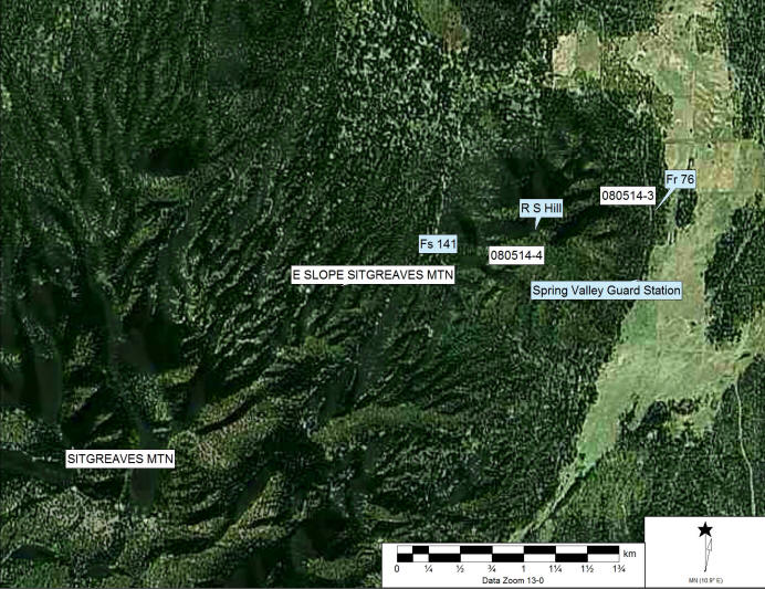
RS Hill and Sitgreaves Mountain with relevant
features and collection localities in August 2014
Kendrick Peak. Sections 1,2,3 R5E,
T23N; Sections 35,36 R5E, T24N USGS Kendrick Peak 7.5' Quad, Kaibab and Coconino National
Forests, south central Coconino County, Arizona. Kendrick Peak is a large composite cone
consisting of five lavas (Robinson 1913). The rhyolite/obsidian is located on the
northeast and east slopes. Robinson describes a "thick flow of black, lustrous
obsidian" on the northeast divide (1913:55). This was not relocated on the survey,
but abundant nodules up to 10 cm in diameter were collected from the east and northeast
slopes near Crowley Park. Nodule densities up to 50 per 5 m2 were recorded
especially toward the northeast divide. Secondary deposition occurs down into the Crowley
Park meadow 5 km east. Obsidian from the Kendrick Peak dome yielded a K-Ar date
of 1.90 ± 0.25 Ma (McKee et al. 1998).
Cortex is generally absent with just gray-black weathered glass. The
glass is vitrophyric with abundant feldspar phenocrysts up to 2 mm in diameter. The color
is gray-black and nearly opaque. Thin flakes show the distinctive cloudy gray translucent
character common in San Francisco obsidians.
The vitrophyric and nearly devitrified fabric in most specimens hampers
control during reduction. Kendrick is not a good raw material for tool production, and was
not detected in any sites in this study. Interestingly, prehistoric reduction of nodules
was common, occurring everywhere on the slopes. Artifactual density was difficult to
estimate in the heavy pine duff. Published references are the same as previous San
Francisco obsidians.
Slate Mountain (Wallace
Tank). Southeast corner of Section 2 R5E, T24N USGS Kendrick Peak 7.5' Quad,
Coconino National Forest, south central Coconino County, Arizona. Jack (1971) and
Schreiber and Breed (1971) both identify Slate Mountain as the source of obsidian here,
but it is actually derived from a small rhyolite/obsidian dome at the base of the south
slope at Wallace Tank. The dome measures a mere 100 meters in diameter by 10 meters high;
the structure, however, is practically entirely composed of equal proportions of black and
mahogany-red and black nodules. A vertical adit dug into the top of the dome to a depth of
2 meters exhibits a series of alternating layers of rhyolite and reddish perlite that
contains mahogany-red and black nodules up to 10 cm in diameter. The nodules are as dense
as 10 per m2 on the surface of the
dome. The cortex and fabric are similar to Kendrick, but the glass is more vitreous, the
phenocrysts are smaller (<2mm) and less dense, and half the nodules are a mixed
mahogany-red and black. Secondary deposition does not occur more than a kilometer away
from the dome structure. Rhyolite from the Slate Mountain dome yielded a K-Ar
date of 1.57 ± 0.04 Ma (McKee et al. 1998).
Prehistoric reduction of the nodules is very common (up to 20-50 flakes
and cores per m2) and there appears
to be no preference for the reddish or black nodules, although subsurface deposits suggest
that the red material may have been more common at one time. One small plainware sherd was
recovered as well as two non-Slate Mountain obsidian artifacts: A unifacially retouched
flake made from Government Mountain material and a biface distal end fragment made from RS
Hill material. Published references include all the above for San Francisco sources in
addition to Mintz (1942).
SLATE MOUNTAIN (WALLACE
TANK)
Element Mean Std
Dev Minimum Maximum N
Ti 649.86 72.71 553.2 773.9 10
Mn
446.30 24.69 424.8 501.0 10
Fe 11617.40 450.53 11178.6 12643.1 10
Rb
115.26 3.91 109.9 122.9 10
Sr
67.38 10.07 61.1 94.8 10
Y 21.90 1.89 18.2 24.7 10
Zr
143.16 4.49 134.5 149.4 10
Nb
45.84 2.51 40.6 48.9 10
Ba
753.62 24.94 716.9 792.4 9
San Francisco Peaks (Fremont-Agassiz
Saddle). Northeast corner of Section 5 R6E, T22N USGS Humphrey's Peak 7.5' Quad,
Coconino National Forest, south central Coconino County, Arizona. This source is located
above 3300 m in elevation on the northwest slope of Fremont Peak near the saddle. The
obsidian, located within a rhyolite lava that measures less than 20 m across, occurs as a
large vitrophyric block about 5 meters in diameter with abundant eroding nodules up to 15
cm in diameter. The cortex is variable from ashy-rhyolite to weathered glass, and the
glass itself is extremely vitrophyric with abundant alkali-feldspar phenocrysts up to 4 mm
in diameter with accessory zircon and rare earth titanosilicates (see Burton 1986). Many
nodules are interbanded with ash. The color is gray-black and translucent around
the margins. The material will not allow controlled fractures and is generally
useless for biface manufacture, although flakes can be removed on the more
vitreous materials. This source has not appeared in archaeological contexts
known to me. There appears to be some prehistoric reduction here, but the density is
light and many 'flakes' could have been produced by freeze-thaw processes quite
easily at this elevation. Published
references include Jack (1971), Moore et al. 1960, Robinson (1913), and Schreiber and
Breed (1971). The rhyolite flow of Core Ridge on San Francisco Mountain
yielded a K-Ar date of 1.10 ± 0.2 Ma (McKee et al.
1998).
Major, minor, and trace elements for
one sample of San Francisco Peak obsidian. Measurements in wt. % or parts
per million as noted.
|
Sample |
Na2O |
MgO |
Al2O3 |
SiO2 |
P2O5 |
K2O |
CaO |
TiO2 |
V2O5 |
MnO |
Fe2O3 |
|
|
% |
% |
% |
% |
% |
% |
% |
% |
% |
% |
% |
|
SFPK-1 |
5.343 |
0 |
12.703 |
74.104 |
0 |
4.3 |
0.232 |
0.063 |
0 |
0.069 |
2.828 |
|
|
|
|
|
|
|
|
|
|
|
|
|
|
|
Cl |
Zn |
Rb |
Sr |
Y |
Zr |
Nb |
Ba |
Pb |
Th |
|
|
|
ppm |
ppm |
ppm |
ppm |
ppm |
ppm |
ppm |
ppm |
ppm |
ppm |
|
|
SFPK-1 |
1573 |
194 |
142 |
11 |
75 |
717 |
141 |
<1 |
67 |
28 |
|
O'Leary Peak/Robinson Crater.
Section 10 R8E, T23N USGS O'Leary Peak 7.5' Quad, Coconino National Forest, south central
Coconino County, Arizona (updated 6.25.98). This is a low density, low quality rhyodacite
glass source on the eastern edge of the field. The nodules, up to 12 cm in diameter, were
collected between O'Leary Peak and Robinson Crater. Rhyodacite units (Moore and Wolfe's
Qoo unit) occur on the slopes of O'Leary and are surrounded by Sunset basalt cinders (see
Moore and Wolfe 1976). The obsidian occurs sporadically in the cinders and rhyodacite, and
the density is generally less than 1 per 5m2. The obsidian is highly vitrophyric (pitchstone). Most looks like a grey-black
glassy rhyodacite. Preferred planes of cleavage are caused by bands of ash in many
nodules, and the cleavage planes and phenocrysts do not allow successful knapping other
than sporadic flake removals. No O'Leary Peak material has been located below
the Mogollon Rim, but artifacts have been reported in the Sunset Crater area. Interestingly, reduced cores and flakes do occur (less than 1 per 5m2) and two plainware and one black-on-white
sherd were recorded. Additional published sources include Jack (1971), Moore et al.
(1960), Schreiber and Breed (1971).
Element
Mean Std Dev Minimum Maximum N
Ti 798 97.5 728 963 5
Mn
677 86.2 560 752 5
Fe
18543 1867.6 16203 20540 5
Rb
74 5.4 68 82 5
Sr
165 8.0 153 175 5
Y 31 1.9 29 33 5
Zr
244 12.8 228 259 5
Nb
48 5.2 43 55 5
Ba
1588 65.3 1519 1688 5
References
Burton, J.H. (1986). Selected Petrologic Applications of
Back-Scattered Electron Imaging. Unpublished Ph.D. dissertation,
Department of Geology, Arizona State University, Tempe.
Jack, R.N. (1971) The source of obsidian artifacts in Northern
Arizona. Plateau 43:103-114.
McKee, E.H., P.E. Damon, M.
Shafiqullah, R.C. Harris, and J.E. Spencer (1998) Compilation of unpublished
USGS and University of Arizona K-Ar dates of volcanic rocks of the San Francisco
Volcanic Field, northern Arizona. Arizona Geological Survey Open File
Report 98-2, Tucson.
Mintz, Y. (1942) Slate Mountain
Volcano-Lacolith. Plateau 14:42-47.
Moore, R.B., and Wolfe, E.W. (1976). Geological map of the
eastern San Francisco volcanic field, Arizona. Miscellaneous Investigations Series,
Map I-953. USGS.
Peterson, B.T. (2013)
The geochemistry of the San Francisco Volcanic
Field: anatomy of a mid-sized intraplate volcanic system from source to surface.
In Rates and Mechanisms of Magmatic Processes: Isotopic and Geochronological
Evidence. Ph.D. dissertation, Department of Earth and Planetary Science,
University of California, Berkeley.
Roberts, T.M. (2008) Footprints
and "fingerprints": a northern Arizona geochemical study of Archaic Period
lithic procurement and mobility. Masters Thesis, Department of
Anthropology, Northern Arizona University, Flagstaff.
Robinson, H.H. (1913). The San Francisco Volcanic Field,
Arizona. U.S. Geological Society Professional Paper 76.
Washington, DC: U.S. Government Printing Office.
Sanders, S.C., Zahrt, J.D., and Bell, G. (1982). Trace and
minor element analysis of obsidian from the San Francisco Volcanic Field using
x-ray fluorescence. Advances in X-Ray Analysis 25:121-125.
Schreiber, J.P. and Breed, W.J. (1971). Obsidian localities in
the San Francisco Volcanic Field, Arizona. Plateau 43:115-119.
Shackley, M.S. (1988). Sources of archaeological obsidian in
the Southwest: an archaeological, petrological, and geological study.
American Antiquity 53:752-772.
Shackley, M.S. (2005). Obsidian: Geology and Archaeology in
the North American Southwest. Tucson: University of Arizona Press.
Wolfe, E.W., Ulrich G.E., Holm, R.F., Moore, R.B., and Newhall, C.G.
(1987). Geologic map of the central part of the San Francisco Volcanic Field, north-central Arizona. USGS Miscellaneous
Field Studies Map MF-1959.

This page maintained by Steve
Shackley (shackley@berkeley.edu).
Copyright © 2015 M. Steven
Shackley. All rights reserved.
Revised: 03 November 2018
 Back to
the SW obsidian source page
Back to
the SW obsidian source page
 To the EDXRF Lab home page