Table 3. Mean and central tendency for Duncan obsidian trace elements (ppm). Only obsidian included in this data table.
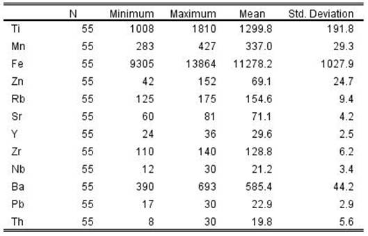
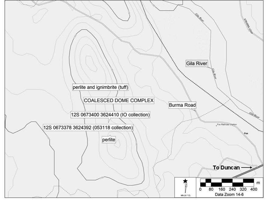
Figure 1. Duncan obsidian source locality and geological features.
THE DUNCAN SOURCE, EASTERN ARIZONA
In 2016 John Roney while directing an archaeological survey for the University of Texas, San Antonio field school north of Duncan, Arizona above the Gila River discovered a potential primary source of obsidian. The initial XRF analysis indicated an elemental composition similar to the Cow Canyon obsidian source located in the Blue Range to the north of the San Francisco and Gila Rivers in northern Greenlee County, Arizona approximately 80 linear km north of Duncan. On 31 May 2018 a geoarchaeological examination and collection at what is now called the Duncan obsidian source indicated that the source is likely a Tertiary (Neogene) period coalesced rhyolite dome complex with scattered small marekanites at light density, most smaller than 30 mm in diameter, and not yet discovered in regional archaeological contexts. The similar elemental composition between Cow Canyon, a major Mogollon-Datil Volcanic Province source of archaeological obsidian in the Southwest, and the Duncan source requires careful analysis when using x-ray fluorescence spectrometry (XRF) in order to discriminate these two sources (Shackley 2005; Shackley et al. 2018).
Geoarchaeological Source Description
The Duncan obsidian source is located in Greenlee County, Arizona at an elevation of 1150 m AMSL approximately 5 km northwest of Duncan, Arizona above Plio-Pleistocene alluvial terraces on the west side of the Gila River and directly above Burma Road (Figure 1). The source is defined by two coalesced rhyolite domes that exhibit remnant obsidian marekanites (nodules) in highly eroded aphyric perlitic tuff and perlite, in a structure that is about 1500 m long oriented northwest/southeast (see Figure 1). Typical of Tertiary (Neogene) rhyolite dome structures in the North American West, the overlying obsidian zone and perlite has generally eroded off the domes in this case into the saddle between the two domes, on the slopes of the domes, and likely eroding into the Gila River system (Fink and Manley 1987; Hughes and Smith 1993; Shackley 2005; see Figure 2 here). No marekanites were discovered in the existing wash below and east of the domes.
There have been no specific geological studies of this structure. The original geological mapping of Greenlee County, Arizona by Wilson and Moore (1958) shows the area here as "Tr - rhyolite, includes tuff and agglomerate", but nothing specific at that scale. More recently Richter et al.'s (1983) geologic map of the Guthrie 1º quadrangle including Graham and Greenlee Counties provides no specific data either. Walker's 1990 Ph.D. dissertation is the best discussion of the Ash Peak area rhyolites, but again his study area was just north of the Duncan domes. We can say that given the above discussion in the geological literature, and the eroded structure of the domes, that the source is likely Tertiary (Neogene) in origin, typical of rhyolite extrusions in the region (Shackley 2005; Shackley et al. 2018), but no specific chronology is available. See discussion below.
Ash Peak and Mogollon-Datil Area Geology
As noted above, Walker's Ph.D. dissertation study examined the Ash Peak volcanics, including what he petrochemically defined as biotite rhyolites, crystal-rich rhyolites, and crystal poor rhyolites, the latter best describes the rhyolite (obsidian) at the Duncan domes, however the composition of the biotite rhyolite with higher Sr and Ba is more similar to the Duncan obsidian composition (Walker 1990:178). No mention of obsidian was made specifically by Walker. These rhyolites are dated to ~20 Ma typical of Neogene silicic events in this part of western North America including the adjacent Mogollon-Datil Volcanic Province (Richter et al. 1983; Shackley et al. 2018). As in the Mogollon-Datil these rhyolites were likely produced by re-melting a granite basement (see Elston 2008; Shackley et al. 2018; Walker 1990). This re-melting of a large plutonic rock body is likely responsible for the similar composition seen in both the Duncan and Cow Canyon obsidian as well as the similarities observed in Mogollon-Datil rhyolites (Shackley et al. 2018; see discussion below).
The marekanite density as seen in May 2018 was rather low, and probably no more than about five per 25 m2. The largest marekanite recovered in 2016 and 2018 was 44.9 mm in largest dimension, but most are half that size or smaller. At least two bipolar flakes were present, so it had been discovered prehistorically.
Thin flakes appear smoky gray and translucent, and seem to be a good media for tool production based on bipolar reduction for XRF analysis (c.f. Shackley 1990, 2005). The megascopic character is different from the Cow Canyon marekanites that are uniformly nearly transparent (Shackley 1995, 2005). While it is likely that the Duncan marekanites have been eroding into the Gila River system since the Tertiary, it does not appear in the archaeological record even in sites in the immediate area (Shackley 2016, 2017). Archaeological sites in the region exhibit a small proportion of Cow Canyon, but the majority are from one of the three major source localities of the Mule Creek Obsidian Complex (Shackley 2005; Shackley et al. 2018). Both Cow Canyon and the Mule Creek Complex source groups erode into the San Francisco and Gila River systems (Shackley 1992, 2005, 2016, 2017; Shackley et al. 2018). While it could certainly just be sampling error (none yet recovered), the Duncan obsidian source is likely such a numerically small source, it probably was not encountered often in prehistory. In Gila River Quaternary alluvium secondarily deposited Cow Canyon and the Mule Creek complex sources are often found in higher densities and larger nodule sizes than at the primary Duncan source. This could also be a factor explaining why Duncan obsidian is not recovered in regional archaeological contexts. Finally, without acquiring Ba when analyzing archaeological obsidian with XRF, it is certainly possible that any Duncan obsidian recovered archaeologically might be mistaken for Cow Canyon, as discussed below. This means that assemblages analyzed by XRF instruments that cannot acquire the higher Z elements could mistakenly assign Duncan obsidian to Cow Canyon. Indeed, all of the analyses completed by the laboratory with the benchtop Quant'X XRF that did not acquire Ba could be in that category, although the low density and small nodule sizes at Duncan and the results in local archaeological contexts suggest that Cow Canyon would dominate in any regional archaeological assemblage. Additionally, as mentioned above, Cow Canyon obsidian is uniformly nearly transparent in flakes and small bifaces and the Duncan marekanites are smoky brown and translucent. While always hazardous, the megascopic character could be used as a first approximation when assigning to source and selecting the non-transparent artifacts for further analysis (see Shackley 2011).
The Mogollon-Datil Volcanic Complex and Cow Canyon Versus Duncan Sources
Both Cow Canyon and the Duncan sources are on the western margin of the Mogollon-Datil Volcanic Complex, a large volcanic field that includes some of the most frequently used obsidian sources in the North American Southwest (Elston 2008; Mills et al. 2013; Shackley 2005; Shackley et al. 2018). The Antelope Creek locality at Mule Creek and Cow Canyon are Neogene Period signature sources that were used from Paleoindian through historic periods (i.e Apache) for tool production, and have been integral in understanding exchange, territory, migration and social networks during the Late Classic of the Southwest (Hamilton et al. 2013; Mills et al. 2013; Shackley 2005, 2007; Shackley et al. 2018).
ACKNOWLEDGEMENTS
Special thanks to John Roney for alerting me to the Duncan source, and taking me up to the domes, and to Bob Hard (UTSA) for letting me run with this data. The fieldwork and laboratory analysis of the Duncan source was undertaken as part of the UTSA project and U.S. Bureau Land Management permitting.
REFERENCES
Elston, W.E.
2008 When Batholiths Exploded: the Mogollon-Datil Volcanic Field, Southwestern New Mexico. In Geology of the Gila Wilderness-Silver City Area, edited by G. Mack, J. Witcher, and V.W. Lueth, pp. 117-128. New Mexico Geological Society Guidebook, 59th Field Conference, Socorro, New Mexico.
Fink, J.H., and C.R. Manley
1987 Origin of Pumiceous and Glassy Textures in Rhyolite Flows and Domes. In The Emplacement of Silicic Domes and Lava Flows, edited by J.H. Fink, pp. 77-88. Geological Society of America Special Paper 212, Boulder, Colorado.
Hamilton, M.J., B. Buchanan, B.B. Huckell, V.T. Holliday, M.S. Shackley, and M. E. Hill
2013 Clovis Paleoecology and Lithic Technology in the Central Rio Grande Rift Region, New Mexico. American Antiquity 78:248-265.
Hughes, Richard E., and Robert L. Smith
1993 Archaeology, Geology, and Geochemistry in Obsidian Provenance Studies. In Scale on Archaeological and Geoscientific Perspectives, edited by J.K. Stein and A.R. Linse, pp. 79-91. Geological Society of America Special Paper 283.
Le Maitre, R.; Bateman, P.; Dudek, A.; Keller, J.; Lameyre, J.; Le Bas, M.; Sabine, P.; Schmid, R.; Sorensen, H.; Streckeisen, A.; Woolley, A.; Zanettin, B.
1989 A Classification of Igneous Rocks and Glossary of Terms: Recommendations of the International Union of Geological Sciences Subcommission on the Systematics of Igneous Rocks, edited by Le Maitre, R.W. Blackwell, Oxford.
Mahood, G., and J.A. Stimac
1990 Trace-Element Partitioning in Pantellerites and Trachytes. Geochimica et Cosmochimica Acta 54:2257-2276.
Mills, B.J., J.J. Clark, M.A. Peeples, W.R. Haas, Jr., J.M. Roberts, Jr., J.B. Hill, D.L. Huntley, L. Borck, R.L. Breiger, A. Clauset, and M.S. Shackley
2013 Transformation of Social Networks in the Late Pre-Hispanic US Southwest. Proceedings of the National Academy of Science 110:5785-5790.
Richter, D.H., B.B. Houser, and P.E. Damon
1983 Geologic map of the Gutherie quadrangle, Graham and Greenlee Counties, Arizona: U.S. Geological Survey Miscellaneous Investigation Map 1455.
Shackley, M. Steven
1990 Early Hunter-Gatherer Procurement Ranges in the Southwest: Evidence from Obsidian Geochemistry and Lithic Technology. Ph.D. dissertation, Department of Anthropology, Arizona State University, Tempe.
1992 The Upper Gila River Gravels as an Archaeological Obsidian Source Region: Implications for Models of Exchange and Interaction. Geoarchaeology 7:315-326.
1995 Sources of Archaeological Obsidian in the Greater American Southwest: An Update and Quantitative Analysis. American Antiquity 60(3):531-551.
2005 Obsidian: Geology and Archaeology in the North American Southwest. University of Arizona Press, Tucson.
2007 Sources of Obsidian at the Murray Springs Clovis Site: A Semi-Quantitative Analysis. In Murray Springs: A Clovis Site with Multiple Activity Areas in the San Pedro Valley, Arizona, edited by C. Vance Haynes, Jr., and Bruce B. Huckell, pp. 250-254. Anthropological Papers of the University of Arizona 71. University of Arizona Press, Tucson.
2011 An Introduction to X-Ray Fluorescence (XRF) Analysis in Archaeology. In X-Ray Fluorescence Spectrometry (XRF) in Geoarchaeology, edited by M.S. Shackley, pp. 7-44. Springer, New York.
2016 Source Provenance of Obsidian Artifacts from Seven Archaeological Sites in Eastern Arizona. Report prepared for Robert Hard, Department of Anthropology, University of Texas, San Antonio.
2017 Source Provenance of Obsidian Artifacts from Three Excavated Sites from the University of Texas, San Antonio 2016 Field School Project in Eastern Arizona. Report prepared for Robert Hard, Department of Anthropology, University of Texas, San Antonio.
Shackley, M.S., F. Goff, and S.G. Dolan
2016 Geologic Origin of the Source of Bearhead Rhyolite (Paliza Canyon) Obsidian, Jemez Mountains, Northern New Mexico. New Mexico Geology 38:52-62.
Shackley, M.S., L.E. Morgan, and D. Pyle
2018 Elemental, Isotopic, and Geochronological Variability in Mogollon-Datil Volcanic Province Archaeological Obsidian, Southwestern USA: Solving Issues Of Inter-Source Discrimination. Geoarchaeology 33:486-497.
Walker, Robert J.
1990 Magmatism and Mineralization of the Ash Peak Area, Arizona: Petrochemical Interpretations. Ph.D. dissertation, Department of Geosciences, Oregon State University, Corvallis.
Wilson, E.D., and R.T. Moore
1958 Geologic Map of Graham and Greenlee Counties, Arizona. Arizona Bureau of Mines, University of Arizona, Tucson.
Zielinski, R.A., P.W. Lipman, and H.T. Millard
1977 Minor-Element Abundances in Obsidian, Perlite, and Felsite of Calc-Alkalic Rhyolites. American Mineralogist 62:426-437.
|
Sample1 |
Locality |
Zn |
Rb |
Sr |
Y |
Zr |
Nb |
Ba |
Pb |
Th |
Rock Type |
|
IO280-1 |
Duncan, AZ |
47 |
140 |
70 |
29 |
129 |
26 |
573 |
18 |
10 |
obsidian |
|
IO283-1 |
Duncan, AZ |
55 |
163 |
74 |
31 |
137 |
23 |
659 |
22 |
21 |
obsidian |
|
IO275-1 |
Duncan, AZ |
46 |
155 |
72 |
36 |
124 |
18 |
579 |
21 |
18 |
obsidian |
|
IO296-1 |
Duncan, AZ |
50 |
155 |
71 |
31 |
129 |
27 |
610 |
24 |
16 |
obsidian |
|
IO274-1 |
Duncan, AZ |
42 |
146 |
68 |
31 |
125 |
20 |
676 |
18 |
19 |
obsidian |
|
IO270-1 |
Duncan, AZ |
43 |
151 |
74 |
33 |
127 |
20 |
579 |
22 |
23 |
obsidian |
|
IO269-1 |
Duncan, AZ |
61 |
157 |
69 |
29 |
137 |
17 |
609 |
24 |
25 |
obsidian |
|
IO276-1 |
Duncan, AZ |
52 |
154 |
75 |
32 |
135 |
19 |
606 |
24 |
22 |
obsidian |
|
IO276-2 |
Duncan, AZ |
46 |
151 |
65 |
30 |
126 |
18 |
567 |
22 |
29 |
obsidian |
|
IO276-3 |
Duncan, AZ |
56 |
160 |
71 |
27 |
136 |
30 |
584 |
23 |
22 |
obsidian |
|
IO276-4 |
Duncan, AZ |
49 |
160 |
73 |
31 |
131 |
20 |
602 |
23 |
25 |
obsidian |
|
IO276-5 |
Duncan, AZ |
59 |
155 |
68 |
31 |
137 |
17 |
593 |
26 |
10 |
obsidian |
|
IO276-6 |
Duncan, AZ |
46 |
163 |
71 |
28 |
128 |
22 |
635 |
23 |
16 |
obsidian |
|
IO276-7 |
Duncan, AZ |
55 |
153 |
71 |
32 |
129 |
19 |
546 |
19 |
26 |
obsidian |
|
IO276-8 |
Duncan, AZ |
54 |
155 |
73 |
30 |
129 |
21 |
604 |
20 |
19 |
obsidian |
|
IO276-9 |
Duncan, AZ |
58 |
147 |
68 |
28 |
132 |
23 |
587 |
24 |
26 |
obsidian |
|
IO276-10 |
Duncan, AZ |
60 |
161 |
73 |
28 |
136 |
25 |
558 |
23 |
20 |
obsidian |
|
IO276-11 |
Duncan, AZ |
59 |
161 |
80 |
27 |
130 |
22 |
558 |
22 |
12 |
obsidian |
|
IO276-12 |
Duncan, AZ |
88 |
150 |
71 |
31 |
123 |
18 |
642 |
22 |
22 |
obsidian |
|
IO276-13 |
Duncan, AZ |
76 |
145 |
67 |
27 |
129 |
23 |
571 |
20 |
10 |
obsidian |
|
IO276-14 |
Duncan, AZ |
93 |
154 |
68 |
29 |
127 |
12 |
581 |
21 |
28 |
obsidian |
|
IO276-15 |
Duncan, AZ |
68 |
160 |
73 |
29 |
132 |
20 |
574 |
22 |
24 |
obsidian |
|
IO276-16 |
Duncan, AZ |
100 |
149 |
70 |
27 |
124 |
28 |
552 |
20 |
15 |
obsidian |
|
IO276-17 |
Duncan, AZ |
102 |
140 |
67 |
27 |
125 |
22 |
558 |
23 |
25 |
obsidian |
|
IO276-18 |
Duncan, AZ |
89 |
147 |
66 |
28 |
111 |
24 |
557 |
17 |
15 |
obsidian |
|
IO276-19 |
Duncan, AZ |
84 |
149 |
68 |
31 |
131 |
19 |
667 |
22 |
29 |
obsidian |
|
IO276-20 |
Duncan, AZ |
75 |
148 |
64 |
27 |
125 |
21 |
561 |
21 |
8 |
obsidian |
|
IO276-21 |
Duncan, AZ |
138 |
141 |
70 |
28 |
121 |
20 |
584 |
20 |
20 |
obsidian |
|
IO276-22 |
Duncan, AZ |
126 |
137 |
63 |
26 |
118 |
20 |
549 |
24 |
27 |
obsidian |
|
IO276-23 |
Duncan, AZ |
134 |
125 |
60 |
27 |
110 |
18 |
482 |
20 |
12 |
obsidian |
|
IO276-24 |
Duncan, AZ |
152 |
133 |
61 |
24 |
117 |
14 |
390 |
18 |
22 |
obsidian |
|
053118-1-1 |
Duncan, AZ |
55 |
159 |
74 |
32 |
138 |
24 |
693 |
26 |
19 |
obsidian |
|
-2 |
Duncan, AZ |
47 |
165 |
76 |
30 |
140 |
21 |
616 |
25 |
20 |
obsidian |
|
-3 |
Duncan, AZ |
74 |
172 |
75 |
36 |
133 |
20 |
589 |
29 |
29 |
obsidian |
|
-4 |
Duncan, AZ |
60 |
162 |
70 |
28 |
136 |
24 |
595 |
24 |
14 |
obsidian |
|
-5 |
Duncan, AZ |
64 |
171 |
78 |
28 |
135 |
21 |
589 |
27 |
21 |
obsidian |
|
-6 |
Duncan, AZ |
54 |
175 |
81 |
33 |
135 |
23 |
565 |
21 |
19 |
obsidian |
|
-7 |
Duncan, AZ |
49 |
153 |
72 |
27 |
132 |
26 |
591 |
22 |
23 |
obsidian |
|
-8 |
Duncan, AZ |
77 |
168 |
77 |
29 |
130 |
24 |
584 |
26 |
23 |
obsidian |
|
-9 |
Duncan, AZ |
58 |
161 |
75 |
33 |
133 |
25 |
618 |
22 |
18 |
obsidian |
|
-10 |
Duncan, AZ |
46 |
160 |
66 |
27 |
125 |
22 |
558 |
22 |
18 |
obsidian |
|
-11 |
Duncan, AZ |
64 |
162 |
78 |
28 |
130 |
27 |
582 |
19 |
16 |
obsidian |
|
-12 |
Duncan, AZ |
52 |
151 |
69 |
31 |
128 |
17 |
572 |
27 |
11 |
obsidian |
|
-13 |
Duncan, AZ |
73 |
158 |
71 |
35 |
130 |
22 |
596 |
25 |
23 |
obsidian |
|
-14 |
Duncan, AZ |
85 |
152 |
72 |
29 |
122 |
20 |
553 |
30 |
18 |
obsidian |
|
-15 |
Duncan, AZ |
75 |
164 |
74 |
30 |
132 |
20 |
592 |
26 |
26 |
obsidian |
|
-16 |
Duncan, AZ |
57 |
156 |
71 |
26 |
131 |
23 |
620 |
23 |
24 |
obsidian |
|
-17 |
Duncan, AZ |
58 |
163 |
71 |
32 |
131 |
20 |
593 |
26 |
20 |
obsidian |
|
-18 |
Duncan, AZ |
59 |
159 |
73 |
28 |
131 |
15 |
583 |
26 |
26 |
obsidian |
|
-19 |
Duncan, AZ |
63 |
154 |
69 |
25 |
126 |
21 |
623 |
24 |
20 |
perlite |
|
-20 |
Duncan, AZ |
53 |
153 |
72 |
31 |
124 |
22 |
605 |
27 |
19 |
obsidian |
|
-21 |
Duncan, AZ |
69 |
156 |
72 |
32 |
132 |
19 |
581 |
26 |
16 |
obsidian |
|
-22 |
Duncan, AZ |
69 |
151 |
69 |
32 |
132 |
22 |
595 |
21 |
12 |
obsidian |
|
-23 |
Duncan, AZ |
65 |
156 |
74 |
28 |
129 |
21 |
569 |
24 |
30 |
obsidian |
|
-24 |
Duncan, AZ |
74 |
156 |
73 |
30 |
125 |
21 |
555 |
22 |
17 |
obsidian |
|
-25 |
Duncan, AZ |
96 |
151 |
71 |
29 |
125 |
23 |
607 |
26 |
12 |
obsidian |
|
-26 |
Duncan, AZ |
48 |
154 |
79 |
32 |
132 |
19 |
568 |
31 |
30 |
tuff |
|
-27 |
Duncan, AZ |
56 |
145 |
71 |
26 |
125 |
21 |
499 |
24 |
27 |
perlite |
|
RGM1-S4 |
|
42 |
147 |
104 |
25 |
219 |
7 |
806 |
24 |
19 |
standard |
1 Those samples with a prefix of "IO" are from the 2016 UTSA collection, and those with the "053118" prefix are from the 2018 collection.
Table 2. Major and minor oxides for a single Duncan obsidian sample and the USGS RGM-1 source standard. All measurements in weight percent (%).
|
Na2O |
MgO |
Al2O3 |
SiO2 |
K2O |
CaO |
TiO2 |
MnO |
Fe2O3 |
Ʃ |
|
|
|
% |
% |
% |
% |
% |
% |
% |
% |
% |
|
|
053118-1-2 |
2.989 |
0 |
12.931 |
73.049 |
6.671 |
1.261 |
0.311 |
0.079 |
2.386 |
99.677 |
|
RGM1-S4 |
4.045 |
0 |
12.918 |
73.857 |
4.933 |
1.433 |
0.292 |
0.05 |
2.228 |
99.756 |
|
USGS RGM-1 recommended |
4.07 |
0.28 |
13.7 |
73.4 |
4.30 |
1.15 |
0.27 |
0.036 |
1.86 |
99.076 |
Table 3. Mean and central tendency for Duncan obsidian trace elements (ppm). Only obsidian included in this data table.
Figure 1. Duncan obsidian source locality and geological features.
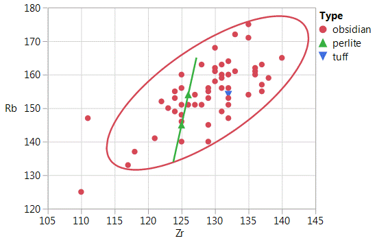
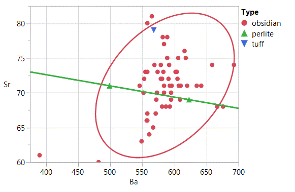
Figure 2. Zr versus
Rb (a) and Ba versus Sr (b) bivariate plots of the Duncan obsidian source
standards, perlite and tuff samples from the Duncan obsidian dome complex.
Confidence ellipses at 95%.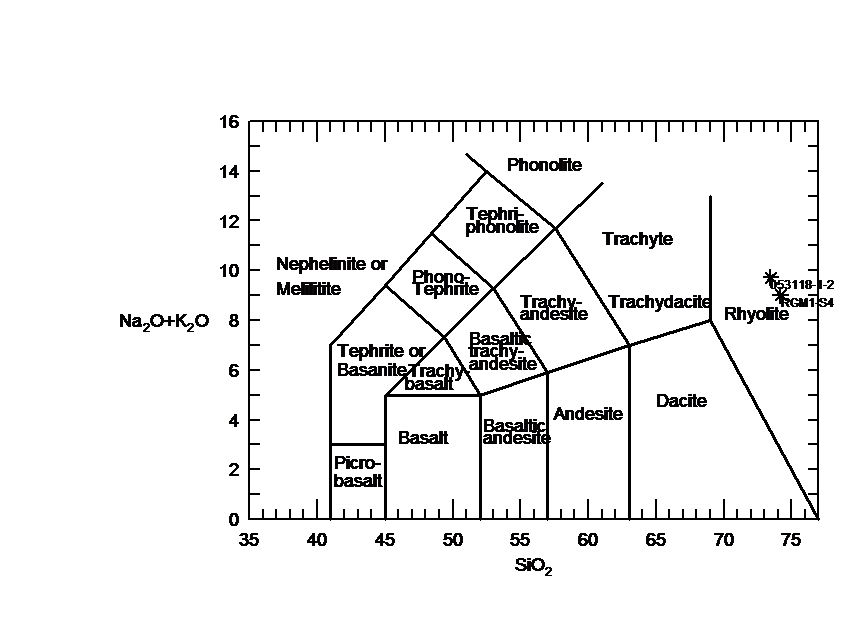
Figure 4. TAS plot of Duncan obsidian sample 053118-1-2 and USGS RGM-1 rhyolite standard (Le Maitre et al. 1989).
![]() Back to SW Obsidian Sources page
Back to SW Obsidian Sources page
Revised: 03 November 2018